Tampilkan postingan dengan label maps and earth. Tampilkan semua postingan

Rabu, 24 Oktober 2012

Trekking the Grand Canyon for Google Maps

In our ongoing effort to create the perfect map—one that’s as comprehensive, accurate and easy to use as possible—we’ve gone well beyond just the streets. Through the Street View feature on Google Maps, you’ve been able to explore panoramic views of amazing places around the world ranging from the Swiss Alps to the Amazon to Antarctica, and a variety of urban cities, university campuses, ancient ruins and ski resorts as well.

Today, demonstrating the rocky and rugged paths we’ll travel to make Google Maps even more complete, we’re collecting imagery from a place no car, trike or snowmobile has ever been before. On its first official outing, the Street View team is using the Trekker—a wearable backpack with a camera system on top—to traverse the Grand Canyon and capture 360-degree images of one of the most breathtaking natural landscapes on the planet.

Operations Manager Steve Silverman (left) and Product Manager Ryan Falor (right) hiking the Bright Angel Trail on the South Rim with Trekkers 

The narrow ridges and steep, exposed trails of the Grand Canyon provide the perfect terrain for our newest camera system. The Trekker—which its operator controls via an Android phone and automatically gathers photos as he walks—enables the collection of high-quality imagery from places that are only accessible on foot.

Falor controlling the the Trekker with his Android device 

This week, photos are being gathered from portions of the South Rim at Grand Canyon National Park, including the ridge, the famous Bright Angel Trail, South Kaibab Trail and more. These panoramic views will soon be live on Google Maps, giving everyone from real-life visitors to armchair travelers the opportunity to marvel at this beautiful, majestic site from the comfort of their computers or mobile devices.

The team hiking the Bright Angel Trail 

So get ready for the virtual adventure that awaits! And in the meantime, we’ll keep on trekken’ and working hard to bring you panoramic imagery of more visually stunning places we have yet to explore and share on Google Maps.

Selasa, 25 September 2012

Dive into the Great Barrier Reef with the first underwater panoramas in Google Maps

Today we’re adding the very first underwater panoramic images to Google Maps, the next step in our quest to provide people with the most comprehensive, accurate and usable map of the world. With these vibrant and stunning photos you don’t have to be a scuba diver—or even know how to swim—to explore and experience six of the ocean’s most incredible living coral reefs. Now, anyone can become the next virtual Jacques Cousteau and dive with sea turtles, fish and manta rays in Australia, the Philippines and Hawaii.


Get up close and personal with sea turtles at Heron Island, Great Barrier Reef

Starting today, you can use Google Maps to find a sea turtle swimming among a school of fish, follow a manta ray and experience the reef at sunset—just as I did on my first dive in the Great Barrier Reef last year. You can also find out much more about this reef via the World Wonders Project, a website that brings modern and ancient world heritage sites online.

At Apo Island, a volcanic island and marine reserve in the Philippines, you can see an ancient boulder coral, which may be several hundred years old. And in the middle of the Pacific, in Hawaii, you can join snorkelers in Oahu’s Hanauma Bay and drift over the vast coral reef at Maui's Molokini crater.


We’re partnering with The Catlin Seaview Survey, a major scientific study of the world’s reefs, to make these amazing images available to millions of people through the Street View feature of Google Maps. The Catlin Seaview Survey used a specially designed underwater camera, the SVII, to capture these photos.


The Catlin Seaview Survey team on location on the Great Barrier Reef, encountering a manta ray

Whether you’re a marine biologist, an avid scuba diver or a landlocked landlubber, we encourage you to dive in and explore the ocean with Google Maps. Check out our complete underwater collection, featuring a Google+ underwater Hangout from the Great Barrier Reef. And you can always explore more imagery from around the world by visiting maps.google.com/streetview.

Explore more underwater images


(Cross-posted on the Lat Long blog)

Kamis, 13 September 2012

Google Maps shows how we spent summer 2012

In the blink of an eye, summer is coming to an end. It feels like it was just yesterday that I was planning out all my summer activities as I eagerly awaited the start of long, sunny days and warm nights.

Before we approach the official end of summer on September 21, our Google Maps team thought it’d be fun to see how those of us in the Northern Hemisphere have spent the dog days. To do this, we reviewed the summer search activity on maps.google.com in several countries between the end of May and the beginning of September. Within each country, a look at some of the top-rising searches and the often-searched landmarks on Google Maps gives us a sense of how people around the world spent their summers.

We’re honored that people rely on the comprehensive and accurate imagery in Google Maps to research, plan, preview and digitally experience distant as well as local destinations across the globe. Take a look and click through for a larger image:


North Americans sought out the best local beaches to help cool off from the summer heat. In comparison, many more people from Spain, Italy and France searched for community swimming pools. In cooler areas of the U.K. the rising Google Maps searches included many indoor activities such as squash, bars and going to the gym. And, as expected, travel was a clear choice for the summer, as indicated by a surge in searches for lodging in almost every region.

Many popular destination searches were located outdoors. National parks and Hawaiian islands were the most popular searches in the U.S., while local parks, zoos, gardens and playgrounds topped Canada’s and Europe’s list. Major landmarks such as the Empire State Building in New York City, Niagara Falls in Canada, the Eiffel Tower in Paris and the Taj Mahal in India also topped the list of often-searched places in Google Maps. And of course, with the Summer Games drawing in international audiences, Wembley Stadium and the Olympic Stadium were two of the most searched for locations throughout the U.K. this summer.

Check out the destinations that captured people’s attention this summer and see how your interests compared to others around the world. We hope you enjoy this look back to remember the fun places we all went with Google Maps this summer, and we can’t wait to help you find your next adventure!


(Cross-posted on the Lat Long blog)

Rabu, 05 September 2012

Making exploration easier for people around the world with Google Maps

Maps keep our spirit of adventure alive by making it easier for us to explore the world around us. That’s why today, we’re making Google Maps even better with new turn-by-turn navigation with traffic conditions, biking directions, Map Maker and new Street View imagery in more locations globally. These improvements are part of our ongoing effort to build the best map we can -- one that’s comprehensive, accurate and easy for you to use.

First, we’re expanding Google Maps Navigation (Beta) with voice guided, turn-by-turn directions in thousands of towns across India. Navigation is one of the most frequently requested features in this region and can be especially helpful when driving in densely populated cities like Delhi or Bangalore. We’re also adding live traffic conditions for major roads with estimated travel times to help you save time and to reduce stress on the road.
Turn-by-turn voice navigation in New Delhi, India

Biking directions and Map Maker are also now rolling out to New Zealanders. Local cyclists can access biking directions directly on Google Maps, and use Map Maker to add bike lanes and trails if their favorite route is missing or they discover a new one. Beyond biking trails, Map Maker can also be used to make the New Zealand map more accurate with details such as new road names, building footprints and more.

Biking directions from Remuera in Auckland to the local Google office

Later today, we’ll also release new Street View imagery for more than 150 university campuses globally. With classes just getting started, freshman students, transfers and even empty-nesting parents can now familiarize themselves with college campuses around the world, including UCLA in the U.S., Pembroke College in the U.K., McGill University in Canada and Sophia University in Japan. These new panoramic views join our growing list of universities whose campuses are already available in Google Maps.


View Larger Map
Royce Hall at the University of California, Los Angeles

Finally, to celebrate all the places you can reach with Google Maps—all seven continents, the sky, the moon and even the depths of the ocean—we made a video that we hope will inspire you to keep exploring.


Keep exploring at maps.google.com/helloworld. Here’s to many new adventures.


(Cross-posted on the Lat Long blog)

Rabu, 29 Agustus 2012

Half a gigameter of biking navigation in 12 countries in Google Maps for Android

Whether you’re a seasoned century rider or a casual beach cruiser, finding the best biking routes can be a challenge. That’s why today we’re bringing mobile biking directions and navigation to the 10 countries where we launched desktop biking directions last month (Australia, Austria, Belgium, Denmark, Finland, the Netherlands, Norway, Sweden, Switzerland and the UK). Plus, we’re adding turn-by-turn, voice-guided biking navigation to Google Maps Navigation (beta) in every country with biking directions. Mount your device on your handlebars to see the turn-by-turn directions and navigation, or use speaker-mode to hear voice-guided directions.
Turn-by-turn biking navigation in Copenhagen

We know there are lots of ways to get from here to there, which is why in 2010, we added biking directions to Google Maps in the U.S. and Canada, and continue to work to bring more biking features to more places. Today, there are more than 330,000 miles (equal to more than 530,000 kilometers, or half a gigameter) of green biking lines in Google Maps. Dark green lines on the map show dedicated bike trails and paths with no motor vehicles, light green lines show streets with bike lanes and dashed green lines show other streets recommended for cycling. Biking navigation even helps you avoid steep hills.
Bike layer showing recommended streets for cycling in Stockholm

Where Map Maker and biking directions are both available, riders can add bike trails, lanes and suggested routes to Google Maps, helping to create a more comprehensive map for everyone living in or visiting their community. Thanks to the contributions of members of the biking community like Todd Scott and our partnership with nonprofits like Rails-to-Trails Conservancy, we’ve added bike data for hundreds of cities and trails to Google Maps in the past two-and-a-half years.

When you’re pedaling from Point A to Point B, we hope biking navigation will make Google Maps for Android more useful to you.


(Cross-posted on the Lat Long blog)

Rabu, 22 Agustus 2012

Google Maps heads north...way north

Search for [cambridge bay] on Google Maps and you’ll fly to a tiny hamlet located deep in the Kitikmeot Region of Nunavut in Canada’s Arctic, surrounded by an intricate lacework of tundra, waterways and breaking ice. High above the Arctic circle, it’s a place reachable only by plane or boat. Zoom in on the map, and this isolated village of 1,500 people appears as only a handful of streets, with names like Omingmak (“musk ox”) Street and Tigiganiak (“fox”) Road.


View Larger Map
Cambridge Bay in Google Maps

There are 4,000 years’ worth of stories waiting to be told on this map. Today, we’re setting out on an ambitious mission to tell some of those stories and to build the most comprehensive map of the region to date. It is the furthest north the Google Maps Street View team has traveled in Canada, and our first visit to Nunavut. Using the tools of 21st century cartography, we’re empowering a community and putting Cambridge Bay on the proverbial map of tomorrow.

The hamlet of Cambridge Bay

We’re not doing it alone, but with the help of the community and residents like Chris Kalluk. We first met Chris, who works for the nonprofit Nunavut Tunngavik, last September at our Google Earth Outreach workshop in Vancouver, where he learned how to edit Google Maps data using Google Map Maker. Today Chris played host to a community Map Up event in Cambridge Bay, where village elders, local mapping experts and teenagers from the nearby high school gathered around a dozen Chromebooks and used Map Maker to add new roads, rivers and lakes to the Google Map of Cambridge Bay and Canada's North. But they didn’t stop there. Using both English and Inuktitut, one of Nunavut’s official languages, they added the hospital, daycare, a nine-hole golf course, a territorial park and, finally, the remnants of an ancient Dorset stone longhouse which pre-dates Inuit culture.

Catherine Moats, a member of the Google Map Maker Team, working with Chris Kalluk and others at the Community Map Up.

Now we’re pedaling the Street View trike around the gravel roads of the hamlet and using a tripod—the same used to capture business interiors—to collect imagery of these amazing places. We’ll train Chris and others in the community to use some of this equipment so they can travel to other communities in Nunavut and continue to build the most comprehensive and accurate map of Canada’s Arctic. As Chris put it to us, “This is a place with a vast amount of local knowledge and a rich history. By putting these tools in the hands of our people, we will tell Nunavut’s story to the world.”

The Street View Trike collecting imagery of Cambridge Bay.

So stay tuned, world. We look forward to sharing with you the spectacular beauty and rich culture of Canada’s Arctic—one of the most isolated places on the planet that will soon be, thanks to the people of Cambridge Bay, just a click away.


(Cross-posted on the Lat Long Blog and new Google Canada Blog)

Mapping the Motor City with Google Map Maker

Hailed as the birthplace of the automotive revolution, the city of Detroit, Mich. is taking its transportation legacy down new paths. As Detroit embraces a greener, non-motorized outlook, cycling is steadily increasing in popularity. The Michigan Trails and Greenways Alliance is facilitating this transition by creating an interconnected statewide system of trails and greenways, including the development of bike paths throughout the Detroit area.

As these new bike paths change the city’s landscape, Motor City residents need a more comprehensive map showing bike friendly routes. Todd Scott, the Detroit Greenways Coordinator, discovered that he could use Google Map Maker—a free tool that allows anyone to make contributions to Google Maps—to add new information on biking paths and trails in and around Detroit. Adding new bike paths not only makes the map more accurate, it also improves biking directions, making it even easier for people to find the quickest routes through town. Anyone can also enhance existing trails by including details such as the official name, surface type and bicycle suitability. Keeping Google Maps updated with the latest information means everyone in the community is able to find and enjoy these new additions to the trail system.

Learn more about Todd Scott and his mission to improve the map for cyclists in Detroit.

Building a more comprehensive, accurate and usable map for local cyclists is just one part of Todd’s mission. From the smallest town to a rapidly evolving city like Detroit, maps reflect the heart of a community. Whether you’re improving directions, adding local businesses or mapping an entire area from scratch, your local expertise will help make life easier for not only you, but all Google Maps users. As Todd says, “It goes beyond map making. It’s a way to take back your neighborhood.”

How are you mapping your world? Join the Map Maker Community and tell us your story.

Jumat, 17 Agustus 2012

Tour Brazil and prehispanic Mexican cities with more Street View imagery in Google Maps

Our ongoing effort to build great maps—ones that are accurate, easy to navigate and cover every corner of the world—continues to progress. Over the last few months, Google Maps has taken people everywhere from the Amazon to Antarctica, and we’re continuing to add imagery of even more places around globe. Beginning this week, you can dive even deeper into Latin America with new Street View imagery of Brazil and Mexico.

Street View first became available for Brazil in 2010, and as of this week, we’ve grown our collection of panoramic imagery to more than 70 cities throughout the country. You’ll now find colonial cities like Fortaleza, architecturally compelling cities like Brasilia and coastal landmarks like Recife, Natal and Salvador. You can even virtually travel to the west side of Brazil and visit Foz de Iguaçu, or if you’re planning an upcoming trip, preview the the area around your hotel as well as nearby shopping malls, historic monuments, restaurants and more. With so many upcoming events, like the 2014 World Cup and the 2016 Olympics, we’re excited to share the riches of Brazil’s cities not only with tourists from around the world, but also with locals who might want to visit a city, neighborhood or landmark they’ve not yet experienced.


Street View imagery of Brazil available before mid-August 2012

Street View imagery of Brazil available beginning mid-August 2012

We’ve also introduced Street View imagery of 30 Mesoamerican archaeological sites in Mexico. Start your adventure by exploring Kukulkan’s Temple, a 1,100-year-old pyramid whose peak is reached by climbing 365 steps, one for each day of the year. When visitors clap their hands, the architectural acoustics at the base of the pyramid’s steps are designed to mimic the sound of the Quetzal, a bird that the Mayans regard as representative of their gods.


View Larger Map
Chichén Itzá, Mexico

Find hundreds of magical stories like this one by visiting the colossal pyramids of Teotihuacan, emblematic sites for the Mayans such as Chichen Itza or seaside archaeological jewels like Tulum. These and other famous sites from around the world can be seen in our Street View Gallery.

We’re always improving the comprehensiveness of our maps so you can experience more imagery from around the world. Whether you’re planning a visit to one of these areas or touring these locations from the comfort of your armchair, we hope you enjoy these captivating new images of Latin America.

Rabu, 15 Agustus 2012

Google Maps now has schedules for more than one million public transit stops worldwide

Since 2005, we’ve collaborated with hundreds of transit authorities around the world to make a comprehensive resource for millions of riders to find out which bus, train, subway or tram can take them to their next destination. Today, Google Maps has public transportation schedules for more than one million transit stops worldwide, in nearly 500 cities including New York, London, Tokyo and Sydney.

Public transportation information is especially useful when it’s in the palm of your hand. Today we’re releasing an update to the Google Maps for Android app (version 6.10) which makes this transit information even more useful. We’ve made some changes to the Transit Lines layer, so that you can select a specific mode of public transportation (train, bus, tram or subway) to display on the mobile map, hiding the other modes. This is helpful in areas where there is a tight concentration of several types of public transit.
Left: Mobile map with all modes of public transit shown; Right: Transit Lines layer in Subway mode

We’ve also updated the layout of station pages to be more useful. Open it by tapping on the name of the station on your mobile map.

Updated station pages show you departure times, lines serving the station and the distance to nearby stations.

In addition to these new transit features, we’ve updated region highlighting, My Places and Location History displays in Google Maps for Android:
  • Now, whenever you search for a city or postal code, the borders of that region are highlighted.
  • Under My Places you’ll notice we’ve added new tabs, which will help you access all your information from a single place; from your saved maps for use offline to your starred places and Custom Maps created on your desktop.
  • If you enable Location History, you’ll be able to browse the places you’ve been on a daily basis with an updated Location History dashboard.
Whether you’re looking for schedule and fare information, directions by public transit or nearby stations, Google Maps puts comprehensive, accurate and useful transit information at your fingertips. Update to the latest version of Google Maps for Android in the Google Play store.

Kamis, 09 Agustus 2012

Conquer the back to school blues with Google tools

August is both an end to the lush freedom of summer and the beginning of another year of student life. As a rising senior at the University of Florida, this time is both exciting and anxiety-inducing. Even though I’m looking forward to many aspects of the school year, there are certain things about college—from book budgets to calculus study sessions—that can make it a headache.

But this fall, I feel more prepared to face the daily student grind. This summer, I had the chance to intern on the communications team at Google and got the inside track on some tools and tricks to make school a snap. For example, did you know there was an extension for Chrome that helps you stay focused on your work? Yup, didn’t think so! So I thought I’d share some of my new favorite tips—my “Survival Guide for Student Life”—to help make it easier for all students to get through the coming months.

Easy ways to coordinate your social and extracurricular life
  • Google+ Hangouts enables you to video chat with up to nine friends from your desktop, mobile phone or tablet. A great feature for when your club needs to discuss some last minute changes for the upcoming meeting.
  • Stay on task with Hangout Apps like Symphonical, which provides a digital wall of sticky notes for virtual brainstorm sessions.
  • With Google+ Events, invite all your friends to your get-together and attach a personalized video greeting to the invitation. During the event, photos from the party can be uploaded to the event page in real-time using Party Mode. So if you have to miss a party due to a study session, you can avoid that pesky FOMO (Fear of Missing Out)!
  • Let your friends know what you’re up to by sharing your Google Calendar with them. Or create a shared calendar just for your study group.
Stay organized and efficient—and be prepared for the unexpected
  • Stop the email flood from the ridiculous number of email lists you signed up for using Gmail’s auto-unsubscribe feature.
  • No more sore eyes from crowded inboxes—Gmail's default mode is Priority Inbox so it automatically sorts your important messages for you.
  • Cite your sources! Use Google Docs’ research tool to investigate highlighted portions of your essay and then generate a citation.
  • Group projects call for collaboration. With Google Drive, you can use shared folders so everyone can access materials without having to email updates to each other.
  • Using your laptop or phone, you can send any documents or presentations saved on your Google Drive to Fedex to be printed, thanks to Google Cloud Print.
Get what you need and where you’re going faster
  • For those of you starting at university this year, Google Maps has 360-degree panoramic Street View imagery for many campuses around the world to give you a preview of your new stomping grounds.
  • Back to school shopping is one of the most fun things about August. Find your way in and out of malls and department stores with indoor Google Maps on Android devices.
  • We college students can’t go too long without homemade food. Search for your next flight home with Flight Search. (If flying makes you a bit queasy, track any care packages by typing the tracking code into the Google search bar.)
  • Stay informed with Google Now. This feature, available on Android devices running Jelly Bean, can update you when the next bus is coming or provide the weather forecast for Saturday’s big game.
Reading, writing, 'rithmetic and... YouTube
  • Don’t break the bank on textbooks. Google Play has millions of FREE (emphasis is important) books readily available such as "Pride and Prejudice" and "Gulliver’s Travels."
  • With the new Nexus 7 tablet, you can take your Google Play books, music, movies, TV shows, magazines and apps (like My Majors and doubleTwist Alarm Clock) with you, wherever you go.
  • Locate hard-to-find books online or at a library near you with Book Search.
  • Put Chrome to work with educational apps
  • Not a fan of traditional note taking? Chromebooks are a super fast and virus-proof laptop. It starts seconds after you boot it and will last through a whole day of classes.
  • A fair portion of us students aren’t fans of mental math. Type any equation into the Google search box to get the answers you need. It can graph functions as well.
  • We know we spend too much of our time watching funny videos on YouTube, but there are video channels that can actually help us learn more about a variety of subjects—from astrophysics to world history. Find more educational channels at YouTube EDU.
I’m resting a bit easier now that I know there are tools that make student life a bit less overwhelming. Here’s hoping you, too, feel armed to face the fall semester—and beyond—with Google in your backpack.


Kamis, 02 Agustus 2012

Celebrate the Kennedy Space Center’s 50th birthday with Street View

For fifty years, NASA's Kennedy Space Center in Florida has been the launch point for a generation of space technology and exploration. Countless enthusiasts (including this one) grew up longing to see a space shuttle up close and walk in the paths of astronauts. Today, a collaboration between NASA and Street View is enabling people around the world to take a trip to the doorway to outer space, and see Kennedy as it transitions into a multipurpose launch complex for the next 50 years of space innovation. This location is our largest special collection of Street View imagery to date, totaling 6,000 panoramic views of the facilities, and expanding our mission to document the world’s most amazing places.


Street View fleet at Kennedy Space Center

Among the images you can now explore online with the click of your mouse are the space shuttle launch pad, Vehicle Assembly Building and Launch Firing Room #4. Gaze down from the top of the enormous launch pad, peer up at the towering ceiling of the Vehicle Assembly Building (taller than the Statue of Liberty) and get up close to one of the space shuttle’s main engines, which is powerful enough to generate 400,000 lbs of thrust. From these vantage points, anyone can live out his or her childhood dream of becoming an astronaut.


Atlantis Orbiter in the Vehicle Assembly Building - View Larger Map


Saturn V rocket on display in the Apollo/Saturn V center - View Larger Map

Even though they recently entered retirement, you can still get an up-close, immersive experience with two of the Space Shuttle Orbiters—the Atlantis and Endeavour —with Street View.


We’d like to thank NASA for making this project possible and giving all of us the chance to digitally walk in the shoes of all of the pioneering astronauts, scientists, engineers and technicians that made our space dreams possible. To explore more of our largest special collection yet, visit our Street View gallery at maps.google.com/nasa.

Kamis, 19 Juli 2012

More detailed maps in parts of Europe, Africa and Asia

Whether you’re travelling abroad or exploring your own city, the maps you carry with you should be comprehensive, accurate and easy to use. We're constantly making improvements to Google Maps to help you find and discover places that are meaningful to you no matter where you are. And today, we’re launching updated maps of Croatia, Czech Republic, Greece, Ireland, Italy, Lesotho, Macau, Portugal, San Marino, Singapore and Vatican City to do just that.

As was the case for past updates, our new maps are more detailed and precise. For example, in Ireland we now have excellent coverage of National Heritage Areas, as well as more detailed coastlines and bodies of water:


We’ve also added more accurate names and locations for major points of interest, such as airports, universities and public squares. Here you can see St. Mark’s Square in Venice, now with accurately aligned canals, 3D buildings and detailed labels of the countless number of places to be discovered.


We’ve also added better and more clearly labelled ferry routes in many places, such as the area below surrounding Naples, Italy. Traveling by ferry is one of my favorite ways to explore a city—I love looking back from the water at the cityscapes—and this improvement will help you find the ferry routes you need to do the same. You can even use Google Maps to get transit-based directions for ferries. We take into account ferry timetables to route you over water just easily as you might follow our driving directions over land.


In addition to the above changes, local roads on these maps are now more accurately distinguished from highways, and multi-lingual names are available for a larger proportion of roads in many of the updated countries. These improvements give you a better visual feel of the location, as well as make it easier to navigate the area when you're on the ground.

Of course, the world around us is always changing, so we’re making our “Report a problem” tool available in each of these countries as well. You can use it to send us a description of any corrections to be made, which we then incorporate into our maps, often within days.

Today’s improvements follow the recent expansion of our collection of Antarctic imagery, and are part of our ongoing effort to build maps that are comprehensive, accurate and easy to use. We've partnered with numerous authoritative sources to ensure that Google Maps is a living reflection of every corner of the globe. After all, a map is only as good as the data behind it. The maps that we've built will help ensure that you get correct and up-to-date information about the world around you.

Update 8:00pm: We're also making certain maps of the 11 countries listed above, plus Egypt, Poland and Ukraine, available offline in Google Maps for Android.

Selasa, 17 Juli 2012

Become an Antarctic explorer with panoramic imagery

In the winter of 1913, a British newspaper ran an advertisement to promote the latest imperial expedition to Antarctica, apparently placed by polar explorer Ernest Shackleton. It read, "Men wanted for hazardous journey. Low wages, bitter cold, long hours of complete darkness. Safe return doubtful. Honour and recognition in event of success." While the ad appears apocryphal, the dangerous nature of the journey to the South Pole is certainly not—as explorers like Roald Amundsen, Robert Falcon Scott and Shackleton himself discovered as they tried to become the first men to reach it.

Back in September 2010, we launched the first Street View imagery of the Antarctic, enabling people from more habitable lands to see penguins in Antarctica for the first time. Today we’re bringing you additional panoramic imagery of historic Antarctic locations that you can view from the comfort of your homes. We’ll be posting this special collection to our World Wonders site, where you can learn more about the history of South Pole exploration.


With the help of the Polar Geospatial Center at the University of Minnesota and the New Zealand Antarctic Heritage Trust, we’ve added 360-imagery of many important spots, inside and out, such as the South Pole Telescope, Shackleton's hut, Scott’s hutCape Royds Adélie Penguin Rookery and the Ceremonial South Pole.

The ceremonial South Pole (View Larger Map)

The interior of Shackleton’s Hut demonstrates the host of supplies used in early 20th century Antarctic expeditions—everything from medicine and food to candles and cargo sleds can be found neatly stored inside. (View Larger Map)

With this technology, you can go inside places like Shackleton’s Hut (pictured above) and the other small wooden buildings that served as bases from which the explorers launched their expeditions. They were built to withstand the drastic weather conditions only for the few short years that the explorers inhabited them, but remarkably, after more than a century, the structures are still intact, along with well-preserved examples of the food, medicine, survival gear and equipment used during the expeditions. Now anyone can explore these huts and get insight into how these men lived for months at a time.

The landscape outside of Robert Falcon Scott’s supply hut conveys just how desolate the area is. For these early explorers, the supply huts were an oasis of warmth and comfort in a cold and inhospitable landscape. (View Larger Map)

This new imagery was collected with a lightweight tripod camera with a fisheye lens—equipment typically used to capture business interiors through the Business Photos program. We worked with this technology because of its portability, reliability and ease-of-use (our Street View trikes wouldn’t be much use in the snow).

The goal of these efforts is to provide scientists and travel (or penguin) enthusiasts all over the world with the most accurate, high-resolution data of these important historic locations. With this access, schoolchildren as far as Bangalore can count penguin colonies on Snow Hill Island, and geologists in Georgia can trace sedimentary layers in the Dry Valleys from the comfort of their desks. Feel free to leave your boots and mittens behind, and embark on a trip to Antarctica.

Posted by Alex Starns, Technical Program Manager, Street View

Kamis, 12 Juli 2012

Street View goes on a road trip through California's national parks


One hot summer day in Yosemite National Park in Northern California, I sat under a tree along a lazy river in awe of the natural beauty around me. I looked out at the majestic granite mountains, the chirping birds and the rustling leaves, and thought about how they were the same that day as they had been thousands of years ago.


View Larger Map

People around the world can now appreciate the beauty and timelessness of the wilderness through Street View. We've recently added 360-degree panoramic imagery for five of California’s national parks—including Yosemite—to Google Maps. In addition, we've refreshed Street View imagery across most of the state. You can now take a virtual road trip practically the entire stretch of California from north to south.

Redwood National Park sits near the California-Oregon border and hugs the Pacific Ocean. It’s most famous for its giant redwood trees—the tallest trees on Earth. With Street View, you can now stare up at them without straining your neck:


View Larger Map

Inland, at Yosemite National Park, you can visit historic Inspiration Point, the site famously photographed by Ansel Adams in “Clearing Winter Storm”. Panning right from the same vantage point, you can see the cliffs of El Capitan and the picturesque Bridalveil Fall waterfall flanking iconic Half Dome, a granite rock formation almost 5,000 feet tall. You can also use Street View to venture into the valley, overlook Glacier Point (visited by John Muir and President Theodore Roosevelt in 1903), explore the more remote upcountry along Tioga Pass road and see the Giant Sequoias in Mariposa Grove.


View Larger Map

You’ve seen the redwoods, now see more enormous trees with a visit to Sequoia & Kings Canyon National Parks, whose namesake trees are the most massive in the world. It would take almost 30 adults linking their outstretched arms to wrap all the way around the largest sequoias. These parks also offer rich and varied landscapes featuring everything from mountains to canyons to caverns.


View Larger Map

The name may be foreboding, but Death Valley National Park, which lies along the California-Nevada border and has the lowest elevation of any spot in North America, is home to a variety of flora and fauna and well worth a visit. With average summer temperatures in this desert environment soaring above 110 degrees Fahrenheit, most people visit in the winter, but Street View lets you check it out any time of year—no sunblock required.


View Larger Map

Slightly north of the U.S.-Mexico border is the fifth and final national park recently added to Street View: Joshua Tree National Park. The gnarly, twisted trees here seem like something straight out of a Dr. Seuss book. Plan your escapades ahead of time from your browser, then pack up your hiking shoes or your mountain bike and hit the trails in this one-of-a-kind desert landscape.


View Larger Map

This only scratches the surface of what California parks have to offer travelers looking to explore the great outdoors. We hope a virtual trip through Street View inspires you to visit these places in person as well. If you need some additional inspiration, I’ll leave you with a quote from naturalist and author John Muir:
Climb the mountains and get their good tidings. Nature's peace will flow into you as sunshine flows into trees. The winds will blow their own freshness into you, and the storms their energy, while cares will drop away from you like the leaves of Autumn.


View Larger Map


Driving down Highway 1 through Big Sur is the ultimate road trip in California.


(Cross-posted on the Lat Long blog)

Selasa, 10 Juli 2012

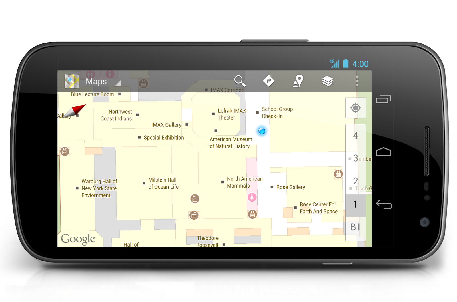
Indoor Google Maps help you make your way through museums

In the past, navigating through museums could be an art form in and of itself. But Google Maps for Android has got wayfinding inside your favorite museums down to a science. With indoor maps and walking directions for U.S. museums now available on your Android phone or tablet, you can plan your route from exhibit to exhibit, identifying points of interest along the way, including between floors.

Today, we’ve added more than twenty popular U.S. museums to our collection of over 10,000 indoor maps that we launched in November: the de Young Museum in San Francisco, the Philadelphia Museum of Art, Cincinnati Museum Center, the Indianapolis Museum of Art, the American Museum of Natural History and 17 Smithsonian museums—plus a zoo!
"My location" in the American Museum of Natural History, New York City

To access the floor plans, simply open Google Maps on your Android phone or tablet and zoom in on the museum of interest. To find the museum, either search for it by name using the magnifying glass icon or, if you’re already there, use the “My location” feature to orient yourself. With the “My location” feature enabled you can even get indoor walking directions.
Indoor walking directions in the National Air and Space Museum—Smithsonian Institution, Washington, D.C.

More museums are adding their floor plans to Google Maps for Android soon, including the SFMOMA, The Phillips Collection, the Nelson-Atkins Museum of Art and the National WWII Museum in New Orleans. If you’re interested in getting your museum’s floor plan included in Google Maps, visit the Google Maps Floor Plans tool.

Along with the Google Art Project, indoor mapping is one more way we’re working with museums to bring greater access to revered cultural and educational institutions around the world. Tap into the latest version of Google Maps for Android in Google Play, and enjoy exploring the art and science of the great indoors.


(Cross-posted on the Lat Long blog)

Selasa, 19 Juni 2012

Street View says "aloha" from Hawaii


Before joining Google, I lived in Hawaii for several years. Now, one look at a photo of palm trees swaying in front of an impossibly blue-green ocean transports me back to the islands—relaxing on the beach and listening to the sound of waves crashing on the shore. If one photo can do that for you, how would you feel if you had access to millions of them?


View Larger Map
The Kohala coast on the Big Island of Hawaii


Our newly expanded Street View coverage of six of Hawaii’s islands enables you to take a virtual vacation to paradise. Explore panoramic imagery of local beach parks, tropical rainforests, volcanic lava fields, oceanfront resorts and more. Can you feel the ocean breeze yet? Now let's do some digital island-hopping...

Oahu
We begin our island adventure on Oahu, home to the capital city of Honolulu and a number of popular destinations. This island has something for everyone, from the top surfing locations of Waikiki Beach and Waimea Bay, to the USS Arizona Memorial Museum and Iolani Palace for history buffs, to the home of the NFL Pro Bowl at Aloha Stadium. Fans of the TV shows “Lost” and “Hawaii Five-0” or movies like “Jurassic Park” will love looking around for filming locations at Kualoa Ranch.


View Larger Map
Kualoa Ranch on the island of Oahu


Maui
Hopping over to Maui, we can sunbathe at oceanfront resorts in Ka’anapali, hit the links on challenging golf courses in Kapalua and learn the hula at the famous Old Lahaina Luau. One of my favorite memories of Maui is driving along the scenic “Road to Hana” with my friends, an experience I can now relive with Street View.


View Larger Map
The “Road to Hana” on the island of Maui


Big Island
We now fly over to the island of Hawaii, also known as the Big Island, where we visit one of the most active volcanoes in the world at Hawaii Volcanoes National Park. We check out the scene in the funky seaside town of Kailua-Kona, explore tropical gardens in Hilo, and climb above the clouds on Mauna Kea. We end our Big Island sojourn with a little oceanside relaxation at the luxurious resorts in Waikaloa, Kamuela or Hualalai.


View Larger Map
Hawaii Volcanoes National Park on the Big Island


Molokai
Over on Molokai, people enjoy the quiet life. With no buildings taller than a coconut tree and not a traffic light to be seen, miles of untouched shorelines and excellent outdoor activities will help you leave the modern world behind.


View Larger Map
The untouched coastlines of Molokai


Kauai
Now let’s jump to the incomparable Kauai, with its jaw-dropping landscapes around every turn. Whether you’re staying in Poipu or Hanalei, be sure to visit Waimea Canyon, which Mark Twain called the “Grand Canyon of the Pacific”. You might also enjoy a leisurely stroll along the coast at Lydgate State Park.


View Larger Map
Waimea Canyon on the island of Kauai


Lanai
Our virtual tour of Hawaii comes to an end on the romantic, tiny island of Lanai, the “pineapple island.” This island has so many memories for me, from the day I proposed to my wife (a few hundred feet from here) to the morning we spent swimming with dolphins in Hulopoe Bay. I can’t wait to go back again!


View Larger Map
An upcountry retreat on the romantic island of Lanai.


We hope this little taste of Hawaii will inspire you to use Street View the next time you're planning a vacation—whether you’re taking a trip around the block, across the world or just down memory lane. Check out a more complete list of Street View’s off-the-road locations in Hawaii here or visit our Scenic Hawaii collection in the Street View gallery.


Street View car at Kualoa Ranch on the windward coast of Oahu.


Aloha!


(Cross-posted on the Lat Long blog)